Scientists have developed new methods of retrieving information about cloud heights, winds, airborne particles, and Earth's surface using data from the Multi-angle Imaging SpectroRadiometer (MISR) instrument orbiting on NASA's Terra satellite.
MISR acquires images of the Earth at nine angles simultaneously, using nine separate cameras pointed forward, downward, and backward along its flight path. Examples of images and atmospheric information that MISR can provide are available at
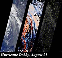
The first example gives three views of Hurricane Debby. One shows the storm's eastern edge as seen by the instrument's downward-looking camera. The others display cloud heights and motions generated by taking advantage of the instrument's multi- angle stereoscopic imaging capability.
The second example illustrates how MISR can detect and measure the abundance of particles, including pollution, in the atmosphere. The downward-looking view of the Appalachian Mountains looks clear, while another image, from a camera viewing at a large slant angle, reveals a thin layer of haze. The third panel is a map of the amount of airborne particulates derived from the images. These demonstrations are based upon samples of MISR's advanced data products.
MISR, built and managed by the Jet Propulsion Laboratory, is one of several Earth-observing experiments aboard Terra, which was launched in December 1999. The MISR science team includes members in the United States, England, and Italy.
