GeoDecisions has selected ORBCOMM to provide global satellite and cellular communications for GeoILS, its innovative, Web-based portal based on IRRIS technology that supports transportation security and logistics for federal and state agencies as well as the private sector.
An information technology company specializing in geospatial solutions, GeoDecisions developed IRRIS in partnership with the U.S. military to support the U.S. Department of Defense (DOD) with logistics, location and proximity analysis, data sharing, collaboration, transportation security, and situational awareness.
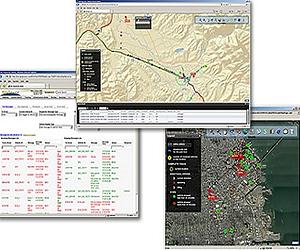
IRRIS is a uniform, effective information management tool for sharing critical, near real-time information among different departments, levels of government and private agencies, facilitating quick and coordinated responses. By leveraging IRRIS, GeoILS takes full advantage of this powerful and secure integrating technology.
ORBCOMM's global satellite and cellular communications capabilities will enable GeoDecisions to integrate, display and deliver worldwide infrastructure data, live vehicle tracking, near real-time weather, and active route conditions in a map format using a single, secure interface.
GeoDecisions will also be able to reduce operating costs and improve overall customer support with ORBCOMM's Web-based service management platform, which will allow them to efficiently manage subscriptions, monitor communications performance and usage as well as provide a comprehensive billing infrastructure for their clients.
"ORBCOMM is proud to provide reliable dual-mode communications to support GeoDecisions' GeoILS application and further enhance their mission to improve security and effective logistics management worldwide," said Brian Bell, ORBCOMM's Executive Vice President of Sales and Marketing.
"ORBCOMM will play a critical role in enabling GeoDecisions to deliver near real-time data necessary for optimum decision making to organize personnel, track assets, and coordinate response globally."
"In today's rapid response world, ORBCOMM's robust satellite and cellular coverage gives GeoDecisions the flexibility, visibility and ubiquity we need to support GeoILS worldwide, our leading technology application for asset and logistics management across many industries," explained Jon Pollack, Senior Vice President for GeoDecisions.
"Leveraging ORBCOMM's global network will enable GeoDecisions to help key decision makers make smarter, faster decisions, maximizing efficiency and productivity for transportation security, logistics, and incident management and response activities around the world."
Currently, premier federal agencies, such as the Federal Emergency Management Agency (FEMA), the U.S. Army and the United States Transportation Command (USTRANSCOM) are successfully using GeoDecisions' GeoILS platform to track and manage valuable resources and assets worldwide.
Share This Article With Planet Earth
