 |
Most Mars Express scientific payload operations were suspended between 22 August and 27 September, due to a period of solar conjunction. During this time, however, radio science (MaRS) experiments of the solar corona were carried out. On the egress from conjunction all spacecraft systems were nominal. After resuming payload operations, the pericentre position in the orbit currently is off by about 1 minute with respect to the frozen orbit prediction. Therefore, it may take up to 2 weeks to get back to the frozen orbit by using nominal wheel off-loadings (no correction manoeuvre is required).
Science Planning Status Planning for the Medium-Term Plan of October 2004 is now finished. Due to the favourable illumination conditions and latitudes with highly valuable targets, a major share of the scientific data is being given to the imaging instruments. During this period, coverage by the DSN 70m antenna is essential due to the intense scientific activities to be carried out. Pointing requirements for the November period have been delivered, and also include high priority for the various imaging instruments. Preparations for the planning of the second eclipse season (from early January 2005 onward) have started. Science planning is being carried out without taking MARSIS into account, until another directive is given. Studies on the safe deployment of the radar antenna for the MARSIS experiment are continuing, and expected to be finished and lead to clear conclusions in the last quarter of 2004. It was decided not to use the opportunity to change the current orbit of Mars Express around day 290. The SWT will establish the programmatic and scientific need to perform such a manoeuvre during the next opportunity for changing the inclination (at day 570), which will still be very effective in modifying the characteristics of the extended mission (eclipse duration and day-night balance). Related Links Mars Express at ESA SpaceDaily Search SpaceDaily Subscribe To SpaceDaily Express 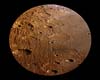 Paris, France (ESA) Oct 06, 2004
This image, taken by the High Resolution Stereo Camera (HRSC) on board ESA's Mars Express spacecraft, shows the Claritas Fossae tectonic grabens and part of the Solis Planum plains. The images were taken during orbit 508 in June 2004 with a ground resolution of approximately 40 metres per pixel. The displayed region is the eastern part of Claritas Fossae and the western part of Solis Planum at longitude 260� East and latitude of about 28� South.
|
| ||||||||||
| The content herein, unless otherwise known to be public domain, are Copyright 1995-2016 - Space Media Network. All websites are published in Australia and are solely subject to Australian law and governed by Fair Use principals for news reporting and research purposes. AFP, UPI and IANS news wire stories are copyright Agence France-Presse, United Press International and Indo-Asia News Service. ESA news reports are copyright European Space Agency. All NASA sourced material is public domain. Additional copyrights may apply in whole or part to other bona fide parties. Advertising does not imply endorsement, agreement or approval of any opinions, statements or information provided by Space Media Network on any Web page published or hosted by Space Media Network. Privacy Statement All images and articles appearing on Space Media Network have been edited or digitally altered in some way. Any requests to remove copyright material will be acted upon in a timely and appropriate manner. Any attempt to extort money from Space Media Network will be ignored and reported to Australian Law Enforcement Agencies as a potential case of financial fraud involving the use of a telephonic carriage device or postal service. |