 |
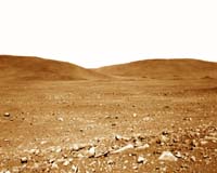
Pasadena - May 06, 2004 Spirit is now less than 1,600 meters away from the base of the "Columbia Hills" after three long sols of driving. Its odometer now reads currently reads over 1,660 meters (1.03 miles) and counting. Sol 118 was a record-breaking driving sol for Spirit. The Gusev Crater rover moved 92.4 meters (303 feet) across the surface in one sol, breaking its previous record of around 90 meters (295 feet). The Opportunity rover still has Spirit beat with a one-sol driving record of 140 meters (459.3 feet). Sol 119 proved to be a more difficult sol for Spirit. An uplink configuration error prevented the sequence load from successfully getting on board the rover. Rover controllers took advantage of the down day by deleting afternoon communication sessions and enabling the rover to charge its battery during a long afternoon nap. It was back to business as usual on sol 120. Before embarking on its drive, Spirit imaged a rock called "Tulula" with the panoramic camera. The rover then successfully executed a blind drive before using the autonomous navigation system to continue into uncharted territory. After reaching the time-of-day driving limit, Spirit turned and performed penultimate (next to last stop) imaging. The next move would have taken the rover 85 centimeters (33.5 inches) to its ultimate stopping point, but did not execute because Spirit was facing a small sand ridge that was perceived as a hazard. Without a penultimate/ultimate image pair, rover controllers could not be sure that the area underneath the rover was clear of hazards for instrument arm deployment. As a result, Sol 121 will be another driving sol that controllers hope will place Spirit in a suitable location to use the instruments on its instrument deployment device.
Spirit's Express Route to 'Columbia Hills' At each stop, or "station," the rover will briefly analyze the area's rocks and soils. Each tick mark on the rover's route represents one sol's worth of travel, or about 60 to 70 meters (200 to 230 feet). Rover planners estimate that Spirit will reach the hills around mid-June. Presently, the rover is stopped at a site called "Plains Station." The color thermal data show how well different surface features hold onto heat. Red indicates warmth; blue indicates coolness. Areas with higher temperatures are more likely to be rocky, as rocks absorb heat. Lower temperatures denote small particles and fewer rocks. During its traverse, Spirit will document the causes of these temperature variations. The map comprises data from the camera on NASA's Mars Global Surveyor orbiter and the thermal emission imaging system on NASA's Mars Odyssey orbiter. Community Email This Article Comment On This Article Related Links Mars Rovers at JPL Mars Rovers at Cornell SpaceDaily Search SpaceDaily Subscribe To SpaceDaily Express Mars News and Information at MarsDaily.com Lunar Dreams and more
 Pasadena CA (JPL) Jan 09, 2006
Last week Spirit completed robotic-arm work on "El Dorado." The rover used all three of its spectrometers plus the microscopic imager for readings over the New Year's weekend. |
|
| The content herein, unless otherwise known to be public domain, are Copyright 1995-2006 - SpaceDaily.AFP and UPI Wire Stories are copyright Agence France-Presse and United Press International. ESA PortalReports are copyright European Space Agency. All NASA sourced material is public domain. Additionalcopyrights may apply in whole or part to other bona fide parties. Advertising does not imply endorsement,agreement or approval of any opinions, statements or information provided by SpaceDaily on any Web page published or hosted by SpaceDaily. Privacy Statement |