 |
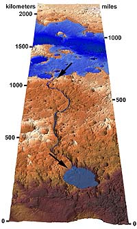
Washington - Jun 24, 2002 Geologists at the Smithsonian's National Air and Space Museum have discovered a large former lake in the highlands of Mars that would cover an area the size of Texas and New Mexico combined, and which overflowed to carve one of that planet's largest valleys. The findings will appear in the June 21 issue of the journal Science. The flood channel, Ma'adim Vallis, is more than 550 miles long and up to 6,900 feet deep, making it larger than Earth's Grand Canyon. "Imagine more than five times the volume of water in the Great Lakes being released in a single flood, and you'll have a sense of the scale of this event," said Ross Irwin, a geologist in the museum's Center for Earth and Planetary Studies (CEPS) and the paper's lead author. Mars is now a cold desert planet but its many dry valleys could indicate that water once flowed on its surface. Recent results from the Mars Odyssey spacecraft have found evidence of water trapped in the near surface of the polar regions. "The size of this lake-1,400 miles long-suggests Mars was warmer and wetter than previously thought," said Robert Craddock, a CEPS geologist and co-author of the paper. Former lakes are considered the most likely places to preserve the record of any past Martian life. Calm water would allow sediments to be deposited slowly, preventing small organisms from being destroyed. The source of water to carve the flood channel had long been a mystery to scientists, who had known very little about Mars' topography prior to the Mars Global Surveyor mission, which has been orbiting Mars since 1997. Detailed elevation data from the Mars Global Surveyor shows the large valley originated nearly full-size at a ridge, much like the spillway of a dam. Late in the lake's history, rising water levels overflowed the lake basin rim, releasing the huge flood as the river cut into this former dividing ridge. What remained was "some of the best geological evidence for a lake found to date on Mars, including clear indications of the former shoreline," Irwin says. Two other smaller lake basins were identified in the region by paper co-author Alan Howard, a geologist at the University of Virginia. All three lakes shared the same water level prior to the flood, indicating the possibility of an ancient water table and suggesting the locations of other dry lake basins on Mars. Such information could be important in determining where to land robotic probes in coming years. Community Email This Article Comment On This Article Related Links More images Smithsonian National Air and Space Museum SpaceDaily Search SpaceDaily Subscribe To SpaceDaily Express Mars News and Information at MarsDaily.com Lunar Dreams and more
 Pasadena CA (JPL) Jan 09, 2006
Last week Spirit completed robotic-arm work on "El Dorado." The rover used all three of its spectrometers plus the microscopic imager for readings over the New Year's weekend. |
|
| The content herein, unless otherwise known to be public domain, are Copyright 1995-2006 - SpaceDaily.AFP and UPI Wire Stories are copyright Agence France-Presse and United Press International. ESA PortalReports are copyright European Space Agency. All NASA sourced material is public domain. Additionalcopyrights may apply in whole or part to other bona fide parties. Advertising does not imply endorsement,agreement or approval of any opinions, statements or information provided by SpaceDaily on any Web page published or hosted by SpaceDaily. Privacy Statement |