 |
Bonn, Germany (SPX) Oct 12, 2009 The High-Resolution Stereo Camera (HRSC) operated by the German Aerospace Center (Deutsches Zentrum fur Luft- und Raumfahrt; DLR) on board the European Space Agency's Mars Express orbiter imaged Daedalia Planum, a sparsely cratered, untextured plain on the Red Planet, featuring solidified lava flows of varying ages. Daedalia Planum lies to the southeast of Arsia Mons, one of the largest volcanoes on Mars. It is 350 kilometres in diameter and rises 14 kilometres high. The plain is dominated by numerous lava flows of varying ages. It lies at about 21 degrees S and 243 degrees E. The images have a ground resolution of approximately 17 metres per pixel and cover about 150 x 75 kilometres or 11 250 square kilometres, an area approximately the size of Jamaica.
Ghost craters and pressure ridges The map shows two lava flows: the younger flow exhibits flow structures, pressure ridges as well as the central lava channel. An older flow visible in the lower portion has a smoother surface due to the gradual accumulation of sediments. Two striking depressions lying at right angles to the lava flow are also visible in the upper portion of the imaged region. These structures are related to grabens that existed earlier (grabens are depressional features formed by faults in the crust). It is likely that the lava flows invaded the grabens partially or filled them up completely. Where a graben was only partially filled, the original dimensions are still recognisable. In the upper left of the nadir image is a portion of this feature that remains unmodified by the younger lava flows. Existing impact craters have also been transformed by the lava flows. The two larger craters show different stages of modification (visible in the 3D image). The largest crater (bottom) was not affected by the lava flow but the ejecta blanket formed during the impact is partially covered in lava. The second largest crater has been flooded almost entirely, although minor portions of the rim are still preserved. It is likely that the lava entered through a breach in the rim, filling the crater up. Fully covered impact craters, whose outlines are still visible, are also known as ghost craters. One such ghost crater is located in the immediate vicinity of the second largest impact crater. The colour scenes have been derived from the three HRSC colour channels and the nadir channel. The perspective views have been calculated from the digital terrain model derived from the stereo channels. The black and white high-resolution images were derived from the nadir channel, which provides the highest detail of all the channels. The High Resolution Stereo Camera (HRSC) experiment on the European Space Agency's Mars Express mission is led by the Principal Investigator (PI) Prof. Dr Gerhard Neukum, who was also responsible for the technical design of the camera. The science team of the experiment consists of 45 Co-Investigators from 32 institutions and 10 nations. The camera was developed at the German Aerospace Center (DLR) under the leadership of the PI, G. Neukum, and built in cooperation with industrial partners (EADS Astrium, Lewicki Microelectronic GmbH and Jena-Optronik GmbH). The experiment on Mars Express is operated by the DLR Institute of Planetary Research, through ESA/ESOC. The systematic processing of the HRSC image data is carried out at DLR. The scenes shown here were processed by the PI-group at the Institute for Geosciences of the Freie Universit�t Berlin in cooperation with the DLR Institute of Planetary Research, Berlin. Share This Article With Planet Earth
Related Links High-Resolution Stereo Camera (HRSC) Mars News and Information at MarsDaily.com Lunar Dreams and more
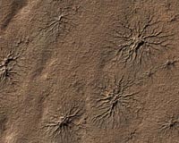
 Radial Channels Carved By Dry Ice
Pasadena CA (SPX) Oct 01, 2009 Spider-shaped features in the south polar region of Mars are carved by vaporizing dry ice in a dynamic seasonal process. This image from the High Resolution Imaging Science Experiment (HiRISE) camera on NASA's Mars Reconnaissance Orbiter includes several of the distinctive features in an area 1.2 kilometers (three-fourths of a mile) wide. It is one of the HiRISE camera team's featured ... read more |
|
| The content herein, unless otherwise known to be public domain, are Copyright 1995-2009 - SpaceDaily. AFP and UPI Wire Stories are copyright Agence France-Presse and United Press International. ESA Portal Reports are copyright European Space Agency. All NASA sourced material is public domain. Additional copyrights may apply in whole or part to other bona fide parties. Advertising does not imply endorsement,agreement or approval of any opinions, statements or information provided by SpaceDaily on any Web page published or hosted by SpaceDaily. Privacy Statement |